 |
[694] c. 1960s ? |

|
[696], Aden
1:75000, c. 1914, Baedeker
|

|
[700],
Part of the South Coast of Arabia, c. 1839,Captain
Haines Indian
Navy,Journal of the Royal Geographical Society of London. Vol. 9
(1839), pp. 125-56

|

|
[701], Two views
of the Gulf of Aden coast drawn by Capt. Haines [1v] (2/2), c.
1839,Capt. Haines,Ref: IOR/X/3224/2
|
|
|

|
[703],
Plan And Sections Of Seera Mole In The Front Bay Of Aden, c. 1844,Henry
W.B. Bell,Plan And Sections Of Seera Mole In The Front Bay Of Aden in
IOR/X/3244
|
 |
[704],
Skeleton Plan eastern portion Aden, c. 1844,William
Jacob (surveyor),
C.W. Grant (surveyor),Plan And Sections Of Seera Mole In The Front Bay
Of Aden in IOR/X/3244
|
 |
[705],
Plan of Aden peninsula showing positions of the Isthmus reservoirs,
proposed new lakes and water tanks, c. 1855,Executive
Engineers Office
Aden, IOR/X/3255
|

|
[707],
Sketch Of The Peninsula Or Cape Of Aden, c. 1846,Copied in the Chief
Engrs. Office Bombay,Sketch Of The Peninsula Or Cape Of Aden’ [1r]
(1/2) Ref: IOR/X/3251
|

|
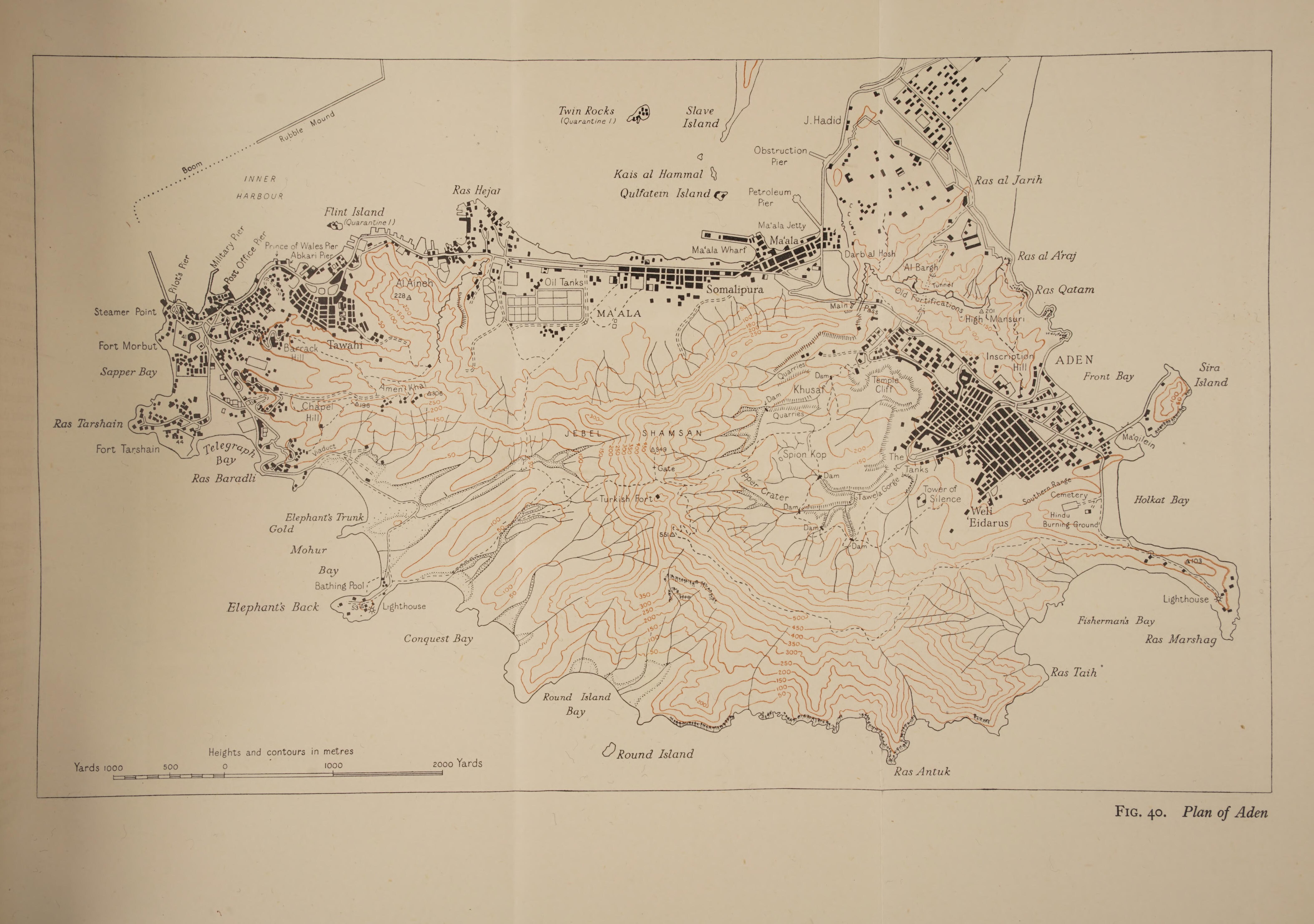
[708], Plan of
Aden, c. 1877
Hunter, F. M. (Frederick Mercer),An account of the British settlement
of Aden in Arabia
|

|
[710],
Military Survey of the Peninsula or Cape of Aden, c. 1839,Captain
Robert Foster, Chief Engineer’s Office, Bombay.
British Plans for the Fortification of Aden [133v] (84/90)
IOR/L/PS/5/378, ff 92-136
|

|
[711],
Military Survey of the Peninsula or Cape of Aden, c. 1839,Captain
Robert Foster, Chief Engineer’s Office, Bombay.,
British Plans for the Fortification of Aden [134r] (85/90)
IOR/L/PS/5/378, ff 92-136
|

|
[712] 1839 British Plans for the
Fortification of Aden [136r] (89/90) IOR/L/PS/5/378, ff 92-136
No. 1. Panoramic Outline of the Range of Mountains and Lower Hills
surrounding the Valley of Aden from Seera to Shersurra as taken from
the top of a Minaret in the Town marked with a cross in the Plan.
No. 2. Outline of Munseerie Range with Seera on the left and Jebel
Hudred on the right as taken from the West End of Base line.
No.3. Outline of Range backing Western Bay as seen from the Pass to
Steamer Point or Point Hedjuff Sketching round from Swageea Island on
the left to Flint Island on the right.
|
|
[713], Map of
Aden, c. 1946,Naval
Intelligence Division,Western Arabia and the Red Sea
|

|
[732], Nautical
chart of the
coast of the Gulf of Aden, c. 1820-1829,Stafford
Bettesworth Haines,The
Several Bays near Cape Aden, on the Arabian Coast, surveyed
Trigonometrically, 1836. Engraved by J.&C. Walker’ [6r] (1/2) :
IOR/X/3630/11
|

|
[766] ‘PLAN OF THE
PENINSULA OR CAPE OF ADEN Exhibiting the Proposed Military Limits. Aden
July 1855’ [1r] (1/2)
IOR/X/3256/2
|


